


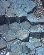
Natural rock formations
near Falls Creek Ski Resort.
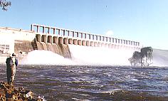
The Hume Dam.
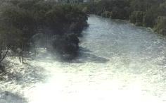
Murray River in flood immediately below
the Hume Dam wall.
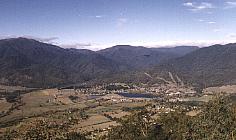
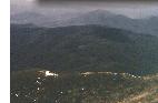
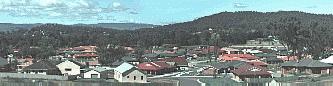
Looking down on the township of Mt Beauty
- gateway to the Alpine region.
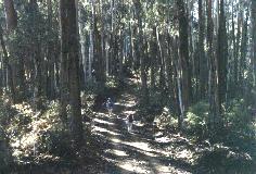
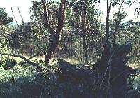
Native forest and bushwalking trails at the base
of Mt Bogong.
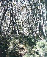
Further up Mt Bogong the tall eucalypts
give way to spindly, low growing
snow gums and other snow tolerant
bush and scrub.
Bushwalking trails become narrower
the closer you get to the snowline.
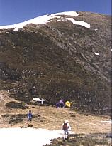
Mt Bogong - above the snow-line in
early spring (October).
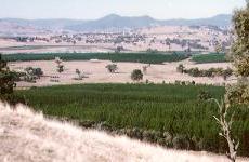
Young pine plantations at the Australian Newsprint Mill
site, near Albury.
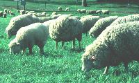
Sheep grazing on lush pastures.
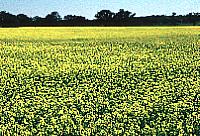
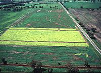
Canola (oilseed) crop.
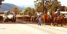
Cattle on the road near Yackandandah, Victoria.
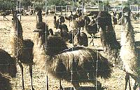
Inquisitive birds on an emu farm,
south of Albury-Wodonga.
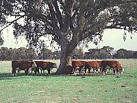
Cattle sheltering under one of the few remaining
gum trees in a clear felled paddock.
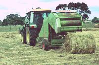
Hay baler rolling bales for animal fodder.
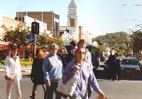
Dean Street, Albury.
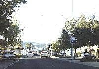
Shady, tree-lined High Street, Wodonga
Sealed (left) and dirt (bottom) roads servicing
country areas.
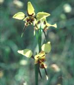
Eastern Hill Flora and Fauna Reserve,
and native orchids, East Albury


In the Landscape -
. . Regional Geography
Albury-Wodonga is situated on the Murray River in the foothills of the Great Dividing Range. Within 100kms of Albury-Wodonga the diverse terrain ranges from snowcapped mountains and cool high river valleys to flat, featureless cropping and pasture lands stretching from horizon to horizon.
The geology of the area is largely granite, volcanic or metamorphosed sediments as base rock, with some areas of unconsolidated Quarternary silts and clays. Vein quartz is very common in both granite and metamorphosed sediments. (Chestnut 1974)
Prior to the construction of the Hume Dam, the profile of the Murray River could change seasonally from a trickle in high summer to a vast sheet of water stretching for miles across during the wetter parts of winter, frequently compounded by the effects of melting snow from the mountains.
Construction of the Hume Dam on the Murray River and Dartmouth Dam on the Mitta Mitta River (which feeds into the Hume Weir) has reduced the regularity and severity of flooding.
The natural fall of the land and subsequent flow of the many rivers and streams feeding the Murray channel any run-off from natural rainfall or melting snow into the Hume Weir or the Murray directly above Albury.
Recent research carried out largely by the Murray Darling Freshwater Research Institute and the CSIRO indicates that regular flooding is not only beneficial to the health of the river, but essential to the survival of many river fish species and eucalypts - particularly the River Red Gum.
The river floodplain is dotted with lagoons which act as nurseries for native fish species. Regular flooding releases the young fish to the river, stranding other, larger adult fish to spawn in the warm lagoons when the river falls to it s normal course.
To the east ...
Looking south-east of Albury-Wodonga the land becomes heavily undulating, with fertile, cool river valleys, supporting a range of agricultural activities from dairy farms to tobacco and hop growing. The growing negative public attitude towards smoking and government incentives to diversify and export have seen the tobacco crops being gradually replaced in favour of the development of alternative crops, for example export quality fresh vegetables grown for the Asian market. Picked, freighted directly to Melbourne and flown out to be in the Asian Fruit and Vegetable Markets within 24 hours!
Other industries to impact on the terrain include the timber industry. Pine forests are dotted throughout the region, feeding timber mills and paper processing plants - principally the Australian Newsprint Mills' plant located on the northern outskirts of Albury.
Whilst large tracts of flat and gently undulating land have been clear felled for agricultural purposes, many of the smaller specialist agriculturalists in the mountain region have plantations - citrus fruits, nuts and berries, in small clearings nestled in amongst native forest.
Moving further up into the highlands is the traditional home of the High Country Cattlemen. The land is rugged, largely untouched by intensive human activities and still largely covered by native forest. Much of the area is designated National Park. Conflicts between the Cattlemen and National Park authorities have seen traditional stock grazing rights denied in many areas.
The Alpine reaches are normally only snow-bound during winter, when a deep mantle of pristine snow covers much of the high-country region. During the warmer months the mountain peaks are generally cold, but bare and wind swept, with occasionally a little snow persisting in the shadows. The highest mountain peaks are around 6514 feet (Mt Bogong) with Mt Kosciusko (Australia s highest mountain) only 90kms to the north east and 800 feet higher at 7311 feet.
The primary industry to affect the Alpine region is tourism. The Victorian Alpine Region boasts numerous fully equipped ski resorts within two hours drive from Melbourne - about an hour and a half from Albury-Wodonga. Even during the summer months the mountains attract many bushwalkers, some optimists carrying skis in their packs in the hope of catching the last of any available snow.
To the west ...
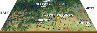
Moving north westerly from Albury-Wodonga the landscape flattens out to large expanses of flat, virtually featureless land. Elevations (height above sea level) recorded for Albury-Wodonga are 539 feet (164 metres) at the Albury Airport and 55 kilometers further west down-river at the Corowa Airport - 469 feet (143 metres).
Close to the river, the region supports a large number of vineyards and associated wineries, interspersed with grazing land - mainly sheep and cattle, with some grain, particularly oil-seeds and fodder cropping.
Moving out from the river, agriculture changes to primarily grazing and cropping. Large expanses of land are regularly sown to wheat, especially further north. Grain spilt by the trucks carrying the annual harvest to the silos feeds large flocks of pink and grey galahs, frequently too over-full to move quickly enough off the roads to safety in the face of on-coming traffic.
Herds of cattle or flocks of sheep being driven to other pastures or grazing on the verges are not an uncommon sight on the country roads, particularly during the dry season when fodder can be scarce.
Most of the flat land within 100kms of Albury-Wodonga has been put to agriculture in one form or another.
Livestock commonly farmed include dairy and beef cattle and sheep for wool and meat. Some diversification from conventional livestock can be found throughout the region with alpacas, emus, ostriches, angora goats, camels, deer and fish farms - mainly trout and yabbies.
Crops sown include wheat, oats, oilseeds, lupins, clover and various other pasture and fodder crops, tobacco, vegetables, citrus and stone fruits, grapes, nuts and berries. The region also supports numerous apiarists (bee/honey farmers).
There is an extensive network of grain silos dotting the landscape and a complex logistical infrastructure supplying the various regional flour and stock feed mills, by road or rail, with the appropriate mix of soft and/or hard grains.
Satellite photographs indicate only a few scattered native forests remain on the flatlands - for example the Chiltern State Forest. Encroaching salinity problems, the rising water table and die-back of many remaining native eucalypts have become environmental concerns recognised largely by the farming community. In response, many programs of re-afforestation and tree planting have been encouraged by governments both federal and state, and recognised as necessary and implemented by the farming community. Among the projects encouraged by government, particularly National Parks and Wildlife and Conservation concerns includes tree corridors throughout the region to allow native animals safe passage to their natural habitual breeding grounds.
The Human Landscape ...
... of the region ranges from scattered family farms, small villages of less than a hundred residents, towns of only a few hundred, to cities like Albury-Wodonga, with a combined urban population of in excess of 72,000. The Albury-Wodonga Statistical District which includes surrounding rural shires has an estimated* total population of 97,090. Other major population centres in the region include Tallangatta, Mt Beauty, Bright, Myrtleford, Beechworth, Wangaratta, Corowa, Rutherglen, Holbrook and Corryong. A more comprehensive list of regional towns and villages can be found here, on the Albury Local Internet Regional Information Project pages.
Roads, highways and railroads cris-cross the region.
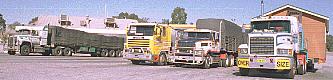
The major Sydney-Melbourne highway, the Hume, passes through Albury-Wodonga, as does the main Sydney-Melbourne rail-road. Other highways head east-west following the river, other major roads head north to Wagga Wagga. A veritable network of sealed roads seemingly radiate outward from Albury-Wodonga servicing the surrounding towns, villages and farms. An equally complex network of unsealed dirt and loose gravel roads service the more rugged mountain areas, the large rural properties and serve as back roads between the sealed roads. Many of the unsealed service roads in the mountain areas are only accessible by four wheel drive. They mainly exist to allow access to telecommunications equipment, fire spotting towers, pine plantations and bushwalking tracks.
From the snow capped Alpine region in the east to the flat, summer dried grazing lands in the west, the Albury-Wodonga area offers a vast diversity of landscapes all within 100 kilometers radius of Albury-Wodonga.
* Population estimates based on the Australian Bureau of Statistics preliminary estimates released for 1996. Source: Development Albury Wodonga 2000 Economic Indicators, April 1997.
![]()
Return to:-